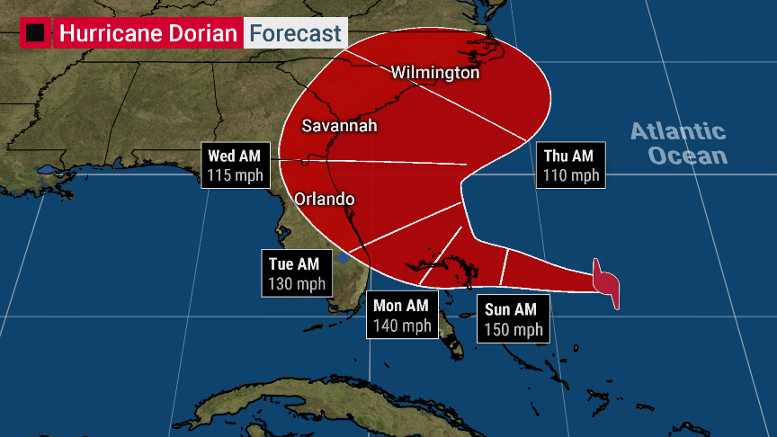
People in Florida are in a lot better shape, based on the forecast track of Dorian than they were yesterday. Now, according to multiple weather reports, Hurricane Dorian my turn north, near the Bahamas and the effects on Florida will be a lot less than a direct hit. That’s the good news. The bad news is Georgia and South Carolina are now in the crosshairs of Dorian when it makes landfall because of the turn it’s expected to make on late Monday.
| Hurricane Dorian my turn north before hitting Florida |
|---|

|
What is known as far:
The Bahamas are going to get crushed by Dorian. A beautiful vacation spot, just 50 miles away from Florida, depending on what part of the Bahamas you are counting. Nassau, the capital is about 250-300 miles from Florida.
Georgia and South Carolina are likely to become the focus of Dorian. While people in Florida can’t let their guards down, because things can change again, it looks like the worst of Dorian will hit somewhere in Georgia or South Carolina Wednesday or Thursday. However, if models continue to trend east, it is possible Dorian will be swept out to sea before hitting any American state.
Hurricane Doria now has sustained winds of 150 miles per hour. This is one of the biggest hurricanes on record and is close to the Labor Day hurricane of 1935.
The liberal media is trying to scare people about global warming being the cause of hurricanes. They are peddling propaganda as usual. Hurricanes form in warm ocean waters, and water temperatures are between 85F-90F near Florida. It has always been like this in the summer months and hasn’t suddenly gone up because of “global warming.”
Keep praying for the US. It might actually work. There is a small possibility that Dorian never makes landfall in the United States. This wasn’t a possibility yesterday.